
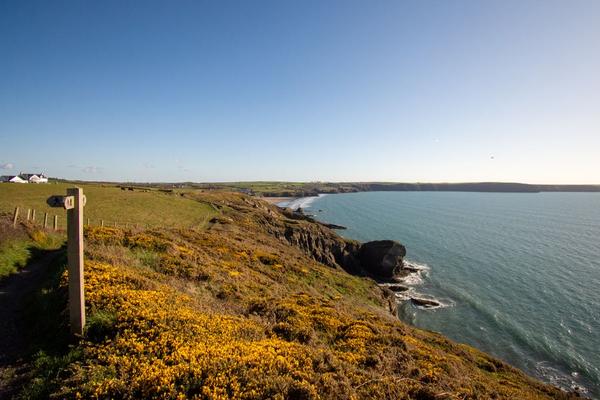
Pembrokeshire coast hiking rewards the walker who plans for the coastline rather than simply counting miles. A short stretch can involve repeated climbs from beaches to headlands, while a longer section may feel surprisingly gentle. Add Atlantic winds, changing tides and small villages with limited buses, and choosing the right route becomes part of the adventure.
The Pembrokeshire Coast Path runs for approximately 186 miles (299 km) from St Dogmaels to Amroth. You do not need to tackle the full National Trail to experience its sea cliffs, sheltered coves and memorable viewpoints. A carefully chosen day walk or three-day itinerary can be just as satisfying.
Choose a stretch that suits your trip
Instead of treating the path as one continuous difficulty level, think about the landscape you want and the effort you can manage. The north has demanding ups and downs; the St Davids peninsula offers exposed headlands and small harbours; and parts of the south combine beaches, woodland and easier access to towns.
Pembrokeshire Coast Path walks worth considering
St Dogmaels to Newport: a challenging northern introduction
The northern coastline makes a striking first impression, with steep-sided valleys, rugged cliffs and long views over Cardigan Bay. This is a rewarding choice for fit walkers who want a proper hiking challenge, not a relaxed beach stroll. Check the official section description carefully before committing: elevation changes and limited escape options can make a day feel harder than its distance suggests.
Porthgain and Abereiddy: industrial history meets wild scenery
A walk linking Porthgain and Abereiddy offers one of the region’s most distinctive contrasts. The former harbour’s industrial remains give way to dramatic rock formations, coastal views and the Blue Lagoon at Abereiddy, a flooded former quarry. This is a strong option for a shorter outing, but allow extra time for uneven ground, photography and a safe return. The Blue Lagoon is a viewpoint, not an invitation to jump from its cliffs.
St Davids peninsula: headlands, bays and flexible walks
A base near St Davids works well for walkers who prefer several day hikes over carrying luggage along the entire trail. Explore sections around St Non’s, Caerfai Bay or Whitesands, checking the length and bus connections for your chosen start and finish. The peninsula is often windy, so an apparently easy outing can feel demanding on exposed headlands.
Marloes and Dale: views with transport planning
West Pembrokeshire delivers wide sea views, maritime scenery and routes around Marloes and the Dale peninsula. It is appealing for a Pembrokeshire walking holiday that mixes hiking with wildlife watching. However, coastal bus services can be seasonal or infrequent. Arrange the return journey before setting off rather than assuming a convenient service will appear at the trailhead.
Tenby, Saundersfoot and Amroth: a southern coastal escape
For walkers who value accommodation choices, cafés and rail connections, the southern end of the trail is practical. Sections around Tenby and Saundersfoot pair beaches with wooded slopes and cliff-top paths, while Amroth marks the trail’s southern terminus. Do not assume the route is flat just because resorts are nearby: the coast still rises steeply in places.
Build a realistic one-day or three-day plan
For a single day, pick one defined section, locate its official start and finish, and confirm both the distance and the amount of climbing. A good first outing is one where you can finish with daylight to spare, rather than one that uses every available hour.
For a three-day trip, consider staying in one base such as St Davids or Tenby and exploring separate routes using buses, trains or a prearranged lift. This reduces luggage weight and lets you choose a less exposed walk if the forecast changes. Travelling outward by public transport and walking back towards your accommodation can also remove pressure to catch the final bus.
For example, a visitor staying near St Davids could dedicate one day to the Porthgain–Abereiddy area, another to a peninsula section, and reserve the third for the best-looking weather window. Exact journeys should be set only after checking current timetables and trail access.
Transport can determine the best route
Linear hiking is the main logistical challenge. Coastal bus routes including the Puffin Shuttle, Strumble Shuttle and Celtic Coaster help connect some western sections, but services and operating days change through the year. Check Pembrokeshire County Council’s current timetable rather than relying on last summer’s information. Around Tenby and the southern coast, rail services can support selected walks, although stations are not always beside the path.
Weather, tides and restricted areas
Wind matters as much as rain. Exposed cliff walks in Wales can become uncomfortable or unsafe in strong gusts, and wet stone steps or muddy slopes demand care. Check a detailed forecast each morning, keep back from cliff edges and avoid shortcuts onto beaches where the rising tide could trap you.
Two particularly important tidal crossings occur between Dale and Milford Haven at the Gann and Sandy Haven. They are passable only within limited windows around low tide; high-water alternatives add considerable road walking. Use current official tide information and route guidance before attempting this section. A low-tide beach shortcut between Broad Haven and Little Haven also requires caution: the designated route uses the road.
Some routes near Castlemartin military training ranges may be diverted or closed during firing activity. Always check official notices before walking there and follow any signed alternative.
What to carry on a coastal hike
Good footwear with reliable grip is worth prioritising over a heavy pack. Carry a waterproof jacket, warm layer, water, food, a charged phone and an offline map or paper backup. Sun protection is useful even on breezy days. Take extra water for remote stretches where shops and cafés are absent. A coastal hiking packing checklist can help you get organised before departure.
Frequently asked questions
How many days does it take to hike the entire Pembrokeshire Coast Path?
Many end-to-end walkers allow roughly two weeks, but the right duration depends on fitness, daily mileage, weather and transport. You can also complete the trail in separate visits over several years.
Is Pembrokeshire coast hiking suitable for beginners?
Yes, on carefully selected shorter sections. Start with a well-described walk near a town or village and check the elevation profile. Some northern and remote stretches are better suited to experienced hikers.
When is the best time for a Pembrokeshire walking holiday?
Late spring through early autumn generally offers longer daylight and more transport options, though rain and strong winds are possible in any month. Quieter seasons can be rewarding if you prepare for shorter days and reduced services.
Can I hike without a car?
Yes. Buses and trains make many sections possible, especially with a town-based itinerary. The key is to verify the day’s return connection before choosing a linear route.
Make the coastline fit your pace
The most memorable Pembrokeshire walks are not necessarily the longest. Choose the coast you most want to see, build in time for the unexpected climb or harbour stop, and make tides and transport part of the plan from the outset. That leaves more attention for the cliffs, wildlife and open water that brought you here.